
Altitude, which refers to the height above sea level, is commonly used to measure mountains, while the geoid is used to measure trenches. The geoid represents the water level on Earth, influenced only by gravity and Earth’s rotation. The Earth’s surface can be considered as an average between the geoid and an elliptical shape.
Mount Everest, located in the Himalayan range, stands at an elevation of 8,850 meters, making it the highest point on Earth. On the other hand, the Mariana Trench is known as the deepest point on Earth, reaching an astounding depth of 10,994 meters. So, how do people determine the height of Everest or the depth of the Mariana Trench? It is widely known that the Earth’s surface is not uniform, so what serves as a reference point for these measurements?
Altitude
Most of us are familiar with the concept of ‘altitude’. In the context of geography, it refers to the height, and sometimes depth, of a landmass, mountain, ocean, and so on. Altitude is measured as the height above sea level. Sea level is chosen as the baseline because there is a continuous body of water connecting all parts of the globe. The uniformity of water levels makes sea level the most suitable reference point for these measurements.
However, we must take into account a counteracting factor – global warming. One of the significant impacts of climate change is the rise in sea levels due to the melting of polar ice caps. Does this mean that altitude measurements will be affected? Will the height of Mt. Everest decrease or the depth of the Mariana Trench increase?
Mean Sea Level (MSL)
To clarify, although sea levels constantly change, these daily, seasonal, or yearly fluctuations do not significantly impact the Mean Sea Level (MSL). As the name suggests, MSL is the average sea level. It is calculated by collecting data on water levels over a period of years and then averaging them. Therefore, minor changes in water levels do not have a significant impact on MSL. However, due to variations in sea levels around the world, map makers no longer use MSL as a reference point today.
 Mt. Everest (Photo Credit: Wikimedia Commons)
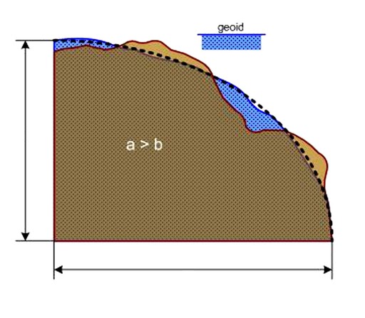
Geoid
The sea level is quite unpredictable, even without global warming. There are numerous factors that contribute to the fluctuation of sea levels, such as tides, weather patterns, anomalies, and so on. Due to these factors, it is nearly impossible to obtain an accurate and fixed measurement of any structure. Hence, the concept of the geoid was introduced.
To grasp this concept better, let’s review some known facts. The Earth is not a perfect sphere; it is actually an ellipse. Additionally, any measurement requires a reference point for calculations. In this case, the sea level serves as the reference point. With this in mind, the geoid is an imaginary representation of the Earth’s water level, which is solely influenced by gravity and the Earth’s rotation. To broaden its application, the geoid assumes that water flows through all areas, even those with landmasses.
If the Earth were perfectly spherical or even elliptical, mathematical formulas could be used for calculations. However, the Earth’s surface is disrupted by mountains, trenches, and other features, causing water to follow an uneven path. Consequently, the geoid’s outline is undulating or wavy. Geoids are utilized as reference points for height and depth calculations. The actual Earth’s surface can be seen as an average between the geoid and an elliptical shape.
 (Photo Credit: Wikimedia Commons)
Naturally, the geoid cannot remain constant due to changing conditions. In certain cases, when there is a significant difference, the geoid is adjusted to align with the prevailing conditions on Earth, resulting in slight changes to altitude measurements. However, these adjustments are not as frequent as those needed if sea level or mean sea level were used as reference points.